
Search Term Record
Metadata
Search Term |
Punta Gorda Isles |
Number of Object records |
12 |
Number of Photo records |
9 |
Number of Archive records |
44 |
Number of Library records |
1 |
Related Records
-

-
2015.002.345 - Blue print of Punta Gorda Isles with plot divisions after construction of canals. Dimensions: 43" x 72"
Map
Record Type: Archive
-
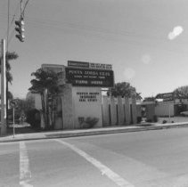
2015.003.011.A.089 - Peeples Insurance Agency
Peeples Insurance Agency on Marion Ave. and Cross St. (2)
Record Type: Photo
-
-
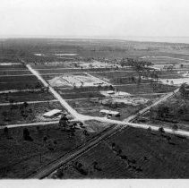
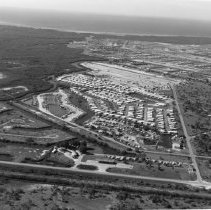
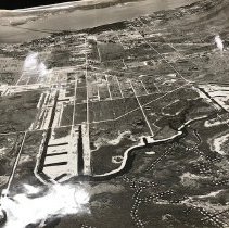
2015.003.011.A.109 - Aqui Esta aerial
Aerial view of Aqui Esta showing housing development circa 1970s
Record Type: Photo
-
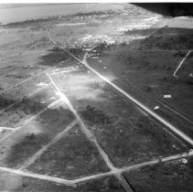
2015.003.011.A.110 - Aqui Esta pre-development
A series of 12 aerial photos of Aqui Esta prior to development in 1956
Record Type: Photo
-
2015.003.011.C.124 - Peeples Punta Gorda
Photocopies of articles, photos concerning Punta Gorda FL
Record Type: Photo
-
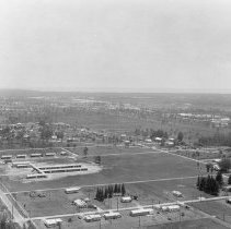
2015.003.011.E.001 - Aerials of Punta Gorda, Port Charlotte
Punta Gorda 1954, Sallie Jones Elementary School, Port Charlotte, Baron Collier Bridge
Record Type: Photo
-
2015.003.011.E.116 - Punta Gorda
Nine aerial photos of Punta Gorda from early 1950s to 1967
Record Type: Photo
-
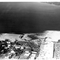
2015.003.034 - Punta Gorda aerials
Vasco Peeples aerials of Punta Gorda, PGI from 1950s, multiple large photographs
Record Type: Photo
-
-
-
2017.001.001 - Copy of Album of Aerial View Photos of Punta Gorda
18 aerial view photos of Punta Gorda including Charlotte Harbor, downtown Punta Gorda, Alligator Creek, Peace River and area that is now Punta Gorda Isles
Record Type: Photo
-
-
-
-
-
-
-