
Archives
Enter a word or phrase to perform a general search across all records in the Archives catalog. You can also browse records in the catalog without performing a search.
Search Tips
- Searches are not case sensitive.
- Searching for multiple words connects them with OR by default. Matching records can contain any of the words.
- Connect multiple words with AND if you only want to see records containing both words.
- Use quotation marks to search for a phrase.
- Place an asterisk (*) at the end of a word as a wildcard.
1200 results found sorted by relevance. Records searched: 1200
-
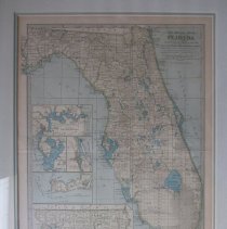
2015.002.088 - Map of Florida with insets of St. Augustine, Jacksonville, Tampa and Key West. Dimensions: 20: x 15.5"
Map
Record Type: Archive
-
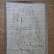
2015.002.109 - Map of the Peninsula of Florida show the present field of surveying in the territory. Dimensions: 10.75" x 18"
Map
Record Type: Archive
-

-
2015.002.115 - Punta Gorda Herald Christmas edition "Santa Watching Sleeping Child"
Newspaper
Record Type: Archive

-
2015.002.126 - Hurricane Storm Tide Atlas of Charlotte Co., Florida. 9 pages. Outlines flood plains and "vacuation routes. Dimensions: 23:" x
Map
Record Type: Archive

-
-
-
2015.002.137 - Black and white aerial photos of Charlotte County showing developing canals before beginning construction of homes. Dimensions: 34" x 32" (4 maps) Duplicate map of 2015.002.165)
Map
Record Type: Archive
-
2015.002.138 - Southern Florida below Lake Okeechobee and Miami-Dade counties. Showing steamship lines from Tampa to Key West for transporting U.S Mail. .Dimensions: 24" x 18"
Map
Record Type: Archive
-
2015.002.144 - Photocopy of Bartow Advance Courier South Florida Railroad Schedule
Schedule
Record Type: Archive

-
2015.002.153 - Enlarged aerial photograph (date unknown) of Gasparilla Pass,north of Boca Grande Island. Dimensions: 26" x 17"
Map
Record Type: Archive
-
2015.002.175 - Photocopy of map of Lemon Bay, (Portion of a larger map). Dimensions: 23" x 44"
Map
Record Type: Archive
-
2015.002.177 - Photocopy of map of Big Sarasota Pass to Casey's Pass. (Portion of a larger map). Dimensions: 23" x 44"
Map
Record Type: Archive
-
2015.002.181 - Topographical map T-5874 of Charlote Harbor & Vining Creek, south of Burnt Store,Dimensions: 32" x 47"
Map
Record Type: Archive
-
2015.002.182 - Topographical map of Fort Ogden in a quadrangle of DeSoto County. (Peace River located on left margin of map). Dimensions 23" x 27"
Map
Record Type: Archive
-
-
2015.002.202 - Map of southern North America and the Bay of Mexico. showing South Carolina, Georgia and Florida Dimensions: 11" x 17"
Map
Record Type: Archive
-
2015.002.211 - Aerial map of Charlotte County, Sec 19, Twp 41, Rge 32. Dimensions: 32" x 36"
Map
Record Type: Archive
-
2015.002.219 - Enlargement of a map of a portion of the Swanee River, Florida showing low water levels. Dimensions: 30" x 52"
Map
Record Type: Archive
-
2015.002.229 - National Geographic map of Mexico, Central America and the West Indies, the Gilbert Grosvenor Edition. Dimensions: 24" x 42"
Map
Record Type: Archive